Pafos 1 – Pafos Castle – Agia Varvara – Episkopi – Tsada – Armou- Agia varvara – Pafos Castle Cycling Route

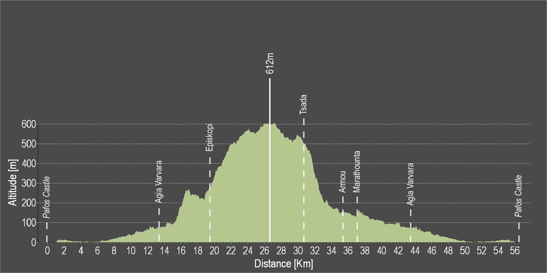
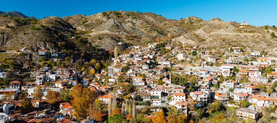
Rozpoczynając jazdę w mieście Pafos, wkrótce zostawisz za sobą miejski zgiełk i znajdziesz się na trasie gajów pomarańczowych i cytrynowych! Trasa prowadzi dalej przez Agia Varvara aż do wioski Episkopi. Po drodze są wspaniałe widoki, ale najbardziej imponujący widok jest ze “Skały”, na której zbudowany jest wiejski kościół poświęcony św. Ilarionowi Wielkiemu. Z tego miejsca można podziwiać niezakłócone widoki na dolinę Ezousa poniżej, a także podziwiać piękno samej natury. Dolina Ezousa to jedna z najpiękniejszych dolin Cypru. Ze względu na wysoką wartość ekologiczną został włączony do europejskiej sieci obszarów chronionych NATURA 2000.

W Episkopi można również odwiedzić Centrum Informacji Ekologicznej.

Idąc dalej, wejdziesz na najwyższy punkt obszaru. Z tego konkretnego punktu widoczność rozciąga się na las Pafos i pasmo górskie Troodos.

Trasa powrotna jest łatwiejsza, ponieważ w większości prowadzi w dół.

Aby pobrać trasę w formacie gpx kliknij tutaj 

Main 10 – Pitsylia – Troodos Cycling Route

Z Alony trasa kieruje się na południowy zachód, biegnie przez Polystypos i wspina się na północny zachód, przechodząc pod szczytem Madari i docierając do wioski Chandria.

W Chandrii skręca w prawo i kieruje się na zachód, przez Kyperounta, aby dotrzeć do skrzyżowania w Karvounas. Z Karvounas kieruje się na południe, wspinając się stromo w kierunku Pano Amiantos, a następnie kieruje się na zachód, wspinając się jeszcze bardziej stromo na plac Troodos. Przed dotarciem do placu mija miejsca piknikowe Almyrolivado i Livadi tou Pasa, a także kemping i miejsce piknikowe tuż przed placem.

Stopień trudności: Dość trudny kurs. Wymaga roweru szosowego z niskimi/łatwymi przełożeniami.
Stan drogi: Drogi utwardzone.
Opis trasy: Trasa ta łączy tereny Pitsylii i Troodos. Jest ciekawą trasą do zwiedzania okolicznych wiosek.

Aby pobrać trasę w formacie gpx kliknij tutaj

Odległość: 26,3 km
Przewyższenie: 1434 m
Najwyższy punkt: 1726 m
Najniższy punkt: 1046 m
Pętla: NIE
Teren: Góra
Nawierzchnia drogi: Utwardzony


Odległość odcinka (km) Całkowity dystans (km)
Alona 0,0 0,0
Polystypos 3,5 3,5
Chandria (Chandria) 5,8 9,3
Kyperounta 3,0 12,3
Karvounas: 5,0 17,3
Amiantos 2,6 19,9
Plac Troodos 6,4 26,3

Lemesos 3 – Lemesos – Fasouri – Pachna – Lemesos Cycling Route

The excursion goes through the western villages of the Lemesos district. It travels past traditional wine-producing villages, goes along the picturesque Fasouri road where the cypress trees growing on either side form a canopy of leaves overhead, and drives past important archaeological sites like that of Kourion.

From the Lemesos port traffic lights, the route heads west towards Zakaki. For about 15km the landscape consists of citrus orchards. Asomatos village and Fasouri settlement are the main orange- producing areas of Lemesos. Along the old Lemesos-Pafos road, the route goes past the chapel of Agios Ermogenis, the entrance to the archaeological site of Kourion and the popular Kourion beach.It then climbs steeply for about 1km and arrives at the Ancient Stadium of Kourion and the Sanctuary of Apollo Ylatis.

Next, the route goes past the military base of Episkopi and the village of Paramali, where it starts to climb to the north towards Avdimou and Prastio until it reaches Pachna, the main wine-producing village of the region.The village is full of vineyards, as are the following villages of Agios Amvrosios and Kivides, which are smaller in size and population.

After Kivides the route is downhill and offers a spectacular view to the east of the town and bay of Lemesos spread out below in all its glory as well as the Akrotiri peninsula and the bay of Episkopi. The straight road that leads to Souni and Kantou is relaxing and enables one to enjoy the countryside. Shortly after Kantou is Erimi, a village located on the old Lemesos – Pafos road.From there the route turns left in an easterly direction, and then right to Kolossi and its medieval castle. The return journey to Lemesos is via Fasouri.

Difficulty rate: It is a relatively long route but it does not present any particular difficulty except for a few steep uphills, which require a bicycle with speeds.
Road condition: Good quality, paved roads throughout.

To download the route in gpx format click here

Distance: 90.8km
Elevation Gain: 1878m
Highest point: 802m
Lowest point: 3m
Loop: YES
Terrain: Mountain
Road surface: Paved
Section Distance (km) Total Distance (km)
Port traffic lights 0,0 0,0
Zakaki 1,8 1,8
Fasouri 2,2 4,0
Trachoni 1,7 5,7
Episkopi 6,3 12,0
Ancient Kourion 0,3 12,3
Sanctuary of Apollon Ylatis 3 15,3
Episkopi Military Base 3,2 18,5
Paramali 5,5 24,0
Avdimou 5 29,0
Prastio Avdimou 4,6 33,6
Pachna 6,6 40,2
Agios Amvrosios 5,7 45,9
Agios Therapon 3,8 49,7
Lofou 4,8 54,5
Kouris Dam 7,8 62,3
Souni-Zanakia Forest 5,4 67,7
Kantou 5,8 73,5
Erimi 3,5 77,0
Ypsonas 1,6 78,6
Kolossi 2,7 81,3
Kolossi Castle 0,8 82,1
Trachoni 3 85,1
Fasouti 1,7 86,8
Zakaki 2,2 89,0
Port traffic lights 1,8 90,8

Lemesos 1 – Lemesos (Limassol) – Ancient Amathous Cycling Route

The route begins from the old port of Lemesos and heads northeast along the coast. It goes through the tourist area of Germasogeia with its many shops, nightclubs, restaurants, hotels and traditional tavernas. The route ends at the archaeological site of Amathous. A short distance down the road is the old chapel of Agia Varvara, once a favourite spot for local fishermen. Just opposite the chapel there is a beautiful eucalyptus grove that provides plenty of shade for swimmers.

Difficulty rate: An easy ride for all types of bicycles.
Road condition: Entirely paved.
Route description: This route is a bicycle tour of Lemesos. There are very few variations in level and are not worth mentioning. It takes cyclists through the tourist area of Germasogeia, ancient Amathous and the nearby chapel of Agia Varvara with its eucalyptus grove and its lovely beach.

To download the route in gpx format click here

Distance: 9.9km
Elevation Gain: 45m
Highest point: 24m
Lowest point: 2m
Loop: NO
Terrain: Flat
Road surface: Paved
Section Distance (km) Total Distance (km)
Old Port 0,0 0,0
Lemesos Coast 1,8 1,8
Germasogeia Tourist Area 3,3 5,1
Ancient Amathus 5,2 10,3
Agia Varvara 0,9 11,2

Lemesos 4 – Germasogeia – Kalo Chorio – Polemidia Cycling Route

This excursion goes through the eastern villages of the Lemesos (Limassol) district as well as some of the mountain villages in the foothills of the Pitsylia region, such as Agros. You can also go down towards Palaichori along theroutes of the Lefkosia (Nicosia) district. The route heads north starting at the Germasogeia roundabout. It climbs through the village, goes past the Germasogeia dam and the villages of Akrounta, Dierona and Arakapas.

At Arakapas, the route turns west and continues climbing steadily to the village of Kalo Chorio where it meets the Lemesos – Pitsylia road. Heading in the direction of Lemesos, a short distance down the road and to the right, is the dirt road that leads to Agios Mamas. From Agios Mamas the route begins to descend along a paved road passing through the villages of Kapileio and Korfi to reach the roundabout of Polemidia on the outskirts of Lemesos.

Difficulty rate: Average.It requires a road bike with at least 20 speeds.
Road condition: Entirely paved roads.

To download the route in gpx format click here

Distance: 65.9km
Elevation Gain: 2007m
Highest point: 729m
Lowest point: 7m
Loop: NO
Terrain: Mountain
Road surface: Paved
Section Distance (km) Total Distance (km)
Germasogeia Tourist Area 0,0 0,0
Germasogeia 3,0 3,0
Germasogeia Dam 3,6 6,6
Akrounta 1,7 8,3
Dierona 15,6 23,9
Arakapas 2,3 26,2
Kalo Chorio 9,5 35,7
Agios Mamas 8,4 44,1
Kapileio 3,1 47,2
Korfi 5,4 52,6
Paramytha 4,6 57,2
Polemidia 8,7 65,9

Lemesos 2 – Ancient Amathous – Governor’s Beach Cycling Route

This excursion is for mountain bike fanatics who will appreciate the technical difficulties involved. Although there are few level changes, the fact that a large part is on rocky ground calls for a good sense of balance and technical skills.

This route starts where the Lemesos-ancient Amathous route ends and goes in the same direction along the old Lemesos-Lefkosia road for 5km until it reaches the Moni flyover. There it turns off onto a dirt road to the right and heads south towards the coast. It goes past a number of industrial units as well as the Moni quarry where it turns left heading east.This part of the route is full of cycling thrills, ending up at Governor’s Beach.

Difficulty rate: Hard and uneven surface.It requires a good quality mountain bike with 24 speeds and front fork suspension.
Road condition: Apart from the first 5km of paved roads, the rest of the route is on an uneven surface.

To download the route in gpx format click here

Distance: 15.4km
Elevation Gain: 214m
Highest point: 67m
Lowest point: 2m
Loop: NO
Terrain: Flat
Road surface: Paved
Section Distance (km) Total Distance (km)
Ancient Amathus 0,0 0,0
Agia Varvara 0,9 0,9
Moni 5,1 6,0
Agios Georgis Alamanos 4,9 10,9
Governor’s Beach 4,5 15,4

Trasy rowerowe na wzgórzu Voroklini

Wzgórze Gerakomoutis leży na wysokości 207 m n.p.m. i znajduje się na nim kaplica poświęcona prorokowi Eliaszowi (gr. Profitis Ilias). Oferuje ekscytujące trasy rowerowe, a także wspaniałe widoki na zatokę Larnaka.

Punkt startowy:  Voroklini Hill
Punkt końcowy: wzgórze Voroklini: Voroklini Hill
Przewyższenie: 207m
Stopień trudności:  Różne poziomy trudności. Wymaga roweru górskiego z co najmniej 21 biegami i zawieszeniem przedniego widelca.
Warunki drogowe:  Teren nieutwardzony
 

Trasa rowerowa w lesie Rizoelia

Mały las Rizoelia położony jest obok ronda na obrzeżach Larnaki, na zachód od wsi Aradippou. Znajduje się tu wiele dróg gruntowych dla miłośników kolarstwa górskiego, a także dla tych, którzy uwielbiają jazdę przez piękny las lub chcą podziwiać widoki ze szczytu wzgórza.

Przewyższenie:  las Rizoelia
Punkt końcowy:  las Rizoelia
Dystans: 65km
Przewyższenie:  20m
Stopień trudności: średnio łatwa trasa po nieutwardzonych drogach. Wymaga roweru górskiego z 21 biegami. Zalecane jest zawieszenie przedniego widelca.
Warunki drogowe:  Teren nieutwardzony.
 

Trasa rowerowa Larnaka 6: Mazotos – Vavatsinia – Kofinou

Trasa rozpoczyna się na stacji benzynowej Mazotos, na obrzeżach miejscowości, i prowadzi dalej drogą w kierunku miejscowości Agios Teodoros i Zygi na południowym zachodzie. Biegnie wzdłuż wybrzeża, aż do miejscowości Zygi.

Stamtąd droga wspina się na północ w kierunku Tochni i dociera do stanowiska archeologicznego Choirokoitia.

Trasa biegnie dalej w kierunku północno-zachodnim, przechodzi przez wieś Choirokoitia i wspinając się stopniowo, prowadzi przez wsie Vavla, Lageia i Ora.  Z Ory skręca w prawo i po 10 km, kierując się najpierw na północ, a następnie na północny zachód, dociera do Vavatsinia. Vavatsinia to dobre miejsce, by odpocząć i coś przekąsić przed powrotem do Korfinou przez wioski Pano Lefkara i Skarinu. Korfinou znajduje się 5 km na północ od Skarinou, na starej drodze Nikozja – Limassol.

Stan dróg: drogi utwardzone na całej długości.

Opis trasy: ta trasa biegnie wzdłuż zachodniej dzielnicy nadmorskiej Larnaki, a następnie wspina się w kierunku wiosek położonych na wzgórzach regionu, mijając stanowisko archeologiczne Choirokoitia i kończy się w Korfinou.

Trasa alternatywna: z Vavli trasa skręca w prawo i wspina się do wioski Kato Drys (6 km), a trzy kilometry później wjeżdża na drogę Skarinou – Vavatsinia, tuż poniżej Pano Lefkara. Ta trasa jest krótsza.

Aby pobrać trasę w formacie gpx, kliknij tutaj.

Dystans:  78.3km
Wysokość wzniesienia: 1882m
Najwyższy punkt:  880m
Najniższy punkt:  1m
Pętla:  NIE
Ukształtowanie terenu: Góry
Nawierzchnia drogi:  Utwardzona

Odcinek Długość odcinka w km Całkowita odległość w km
Stacja paliw Mazotos 0,0 0,0
Zygi 18,2 18,2
Tochni 5,6 23,8
Choirokoitia 5,1 28,9
Vavla 8,4 37,3
Lageia 2,2 39,5
Ora 6,7 46,2
Agioi Vavatsinias 2,9 49,1
Vavatsinia 6,7 55,8
Pano Lefkara 9,6 65,4
Skarinou 7,8 73,2
Korfinou 5,1 78,3

Główna trasa rowerowa 2: Lythrodontas – Agros

Z wioski Lythrodontas wjeżdżamy bezpośrednio do lasu Machairas i po pokonaniu 915 m wysokości docieramy do klasztoru Machairas. Stamtąd trasa kieruje się na zachód i prowadzi przez małe wioski Lazanias i Gourri, gdzie skręca na południe do Farmakas.
Z Farmakas kieruje się na południowy zachód i opada w kierunku głównej drogi Nikozja – Palaichori, z zaporą wodną Palaichori po lewej stronie. Z tego miejsca droga skręca w lewo i prowadzi przez Apliki, wznosząc się stopniowo przez 5 km, aż do Palaichori, skąd prowadzi na południe do wioski Agros, położonej 13,9 km od Palaichori.

Stan dróg: w przeważającej części trasa prowadzi po drogach utwardzonych.
Opis trasy: ta wycieczka została specjalnie zaprojektowana tak, aby połączyć wjazd do lasu Machairas z zjazdem do Limassol, przejazd przez okolice Pitsylia lub dalej do Troodos, a nawet powrót do Nikozji alternatywną trasą.

Aby pobrać trasę w formacie gpx, kliknij tutaj.

Dystans: 51.0km
Wysokość wzniesienia:  2430m
Najwyższy punkt:  1266m
Najniższy punkt: 419m
Pętla: NIE
Ukształtowanie terenu: Góry
Nawierzchnia drogi: Utwardzona


Odcinek Długość odcinka w km Całkowita odległość w km
Lythrodontas 0,0 0,0
Mantra tou Kampiou 7,3 7,3
Agios Onufrious 3,3 10,6
Klasztor Machairas 4,5 15,1
Gourri 8,4 23,5
Farmakas 6,2 29,7
Apliki 4,9 34,6
Palaichori 2,5 37,1
Agros 13,9 51,0

Distance: 51.0km
Elevation Gain: 2430m
Highest point: 1266m
Lowest point: 419m
Loop: NO
Terrain: Mountain
Road surface: Paved