Da Costa

This lovely, tranquil dive is situated in a protected area and is perfect for introductory dives, easing beginners in with a walk-in entry; a mostly flat and sandy surface; a lack of waves, and small, unassuming marine creatures.

Turtles are frequently sighted – at just 2-4 metres into the dive. Diving a little deeper, the series of submerged statues – including a mermaid, a lion and a dwarf – are also handy tools for beginners to practise their buoyancy.

The sandy bottom of Posidonia seagrass offers the perfect environment for cuttlefish to lay their eggs whilst the parents swim protectively around their future offspring. Barracuda and seahorses can also be spotted.


Location: Protaras, Ammochostos
GPS Coordinates:35° 0’24.58″N 34° 3’44.63″E
Type of Site:Shore Dive
Depth:11 metres
Visibility:15+ metres
Access:Shore (walk-in)
Qualification Required: Open Water
Dive Category:Recreational Diving


For the Da Costa diving route click here

Green Bay Cave

Green Bay Cave is a series of majestic through and through caves and caverns located close to the Green Bay diving site.

This easy dive is known for its spectacular marine life and is home to a large variety of fish, corals and colourful sea flora. Cave dwellers include lionfish, moray eels and turtles, amidst more commonly sighted species such as barracuda, bream, damselfish, rainbow wrasses and zebra breams.

The site is also great for scooter diving.

Location:Cape Gkreko – Protaras, Ammochostos
GPS Coordinates:34° 59’57.28″N 34° 4’11.37″E 
Type of Dive Site:Rocky bottom, small caverns (through and through), also suitable for scooter diving
Depth:17 metres
Visibility:20+ metres
Access:Shore
Qualification Required: Open Water
Dive Category: Recreational Diving

Liberty Shipwreck

The Liberty wreck was sunk in the Protaras Marine Protected Area (MPA) in 2009 to create an artificial reef, later joined by the Nemesis III wreck that was sunk in 2013.

The wreck – formerly a Russian cargo ship – sits upright, just 90 metres from the Nemesis III, which makes it ideal for scooter diving. This is made all-the-more interesting thanks to a two-metre cross that was submerged there by famous Russian explorer Feodor Konyukhov and added to with a statue of the Mother of God later by a Russian dive school.

The site is safe and ideal for basic wreck diving and rewards the diver with abundant marine life, including bright anemone on the deck. A torch is recommended to fully appreciate the dazzling colours. Other marine life includes bream, groupers, lionfish, moray eels, sea slugs, squid and tube worms.


Location: Protaras, Ammochostos
GPS Coordinates: 35° 2’59.47″N 34° 2’11.76″E
Type of Dive Site: Wreck (also suitable for scooter diving)
Depth: 27 metres
Visibility: 20+ metres
Dimensions: 37 metres long / 10 metres wide
Access: By boat
Qualification Required: Advanced Open Water / Boat Diver
Dive Category: Recreational Diving


For the Liberty diving route click here

Cyclops

Considered to be one of the most beautiful dive sites of the Cape Gkreko area, this site takes its name from the cave above that legend tells was the hideout of the mythical one-eyed Cyclops. Rather, it is a magnificent, half-submerged grotto with a stunning topography of huge boulders, rocks, seagrass and sand – including a sandy, uphill path between meadows of Posidonia seagrass.

The versatility of the site makes it popular as it offers each diving level a different experience. It is ideal as a practise site for mapping, night diving, navigation and deep dives, as well as snorkelling. As such, both beginners and technical divers will enjoy exploring the interesting underwater landscape and the cliff’s marine life, including bream, grouper, lionfish, moray eels, nudibranch, sea urchins and starfish, among other species.


Location: Konnos Bay – Protaras, Ammochostos
GPS Coordinates: 34° 59’10.24″N 34° 4’35.99″E
Type of Dive Site: Rocky, Sandy, Drop-off (cliff)
Depth: 45 metres
Visibility: 20+ metres
Access: Shore (difficult) / By boat
Qualification Required: Open Water
Dive Category:Recreational and Technical Diving


To view the Jetski click here

Kampos Forest Heritage Museum

The museum lies just a few kilometers away from Kykkos Monastery and overlooks from one side, the Morphou Bay and from the other, Mount Olympus.
The museum is divided in two sections and the visitor can be guided using interactive media and attractive photo displays. On the ground floor, the display walks through the history of the Cypriot forest from the Bronze Age through to the British Colonial era.
In the basement of the museum, the more recent history of wood processing and logging is displayed through traditional tools and machinery as well as digital media.

In the museum botanical garden there are various specimens of local and endemic species.

Region: Lefkosia
Address: Community Council of Kampos, 2, Chr. Kalaitzi, 2863 Nicosia
Contact No: Tel: 22942450
Operating Hours: Opening Hours: Please contact Mob. + 357 99645400
Operating Period: All year round
Closed on Public Holidays
Entrance Fee: €3,00,  €2,00 reduced,  Family €10
Disabled Access: Entrance ramp in the property.
Opening and closing times are subject to alterations without notice. Visitors are advised to check before visiting.

Takis Pattichis Museum of Industrial Pharmacy

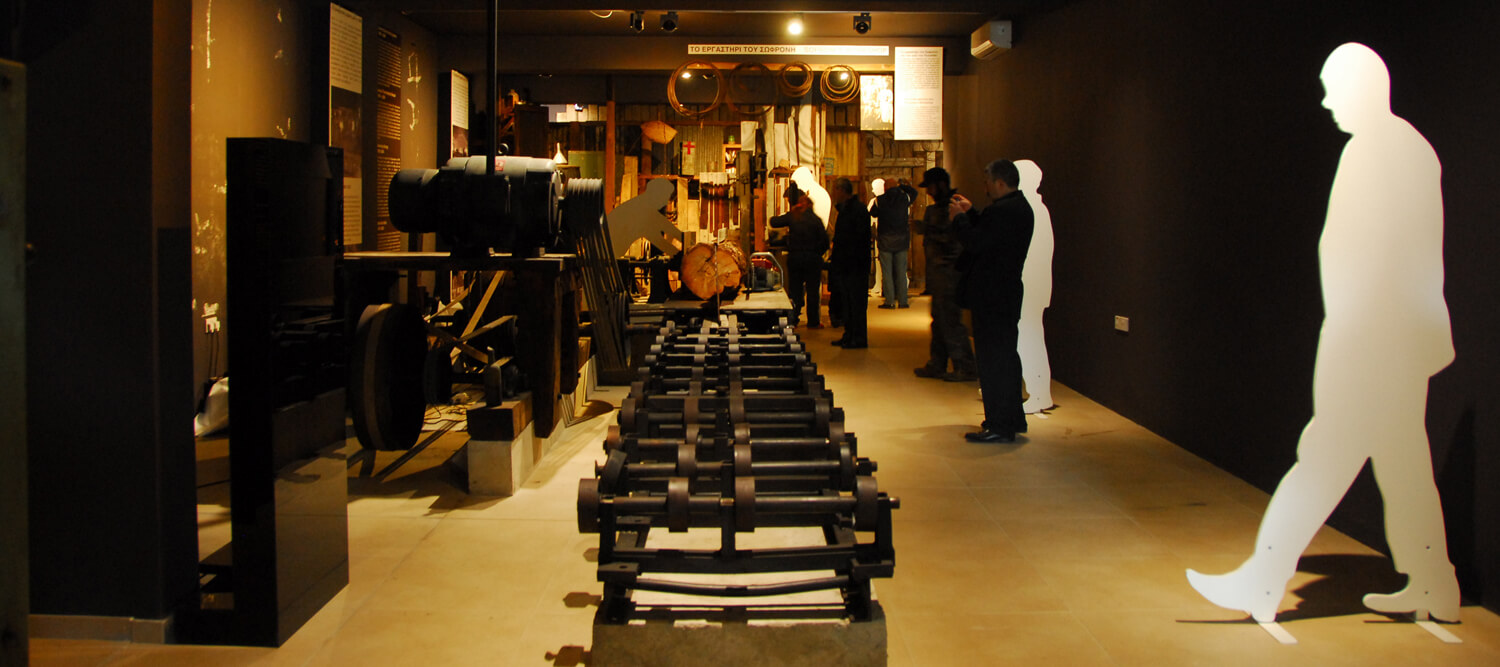
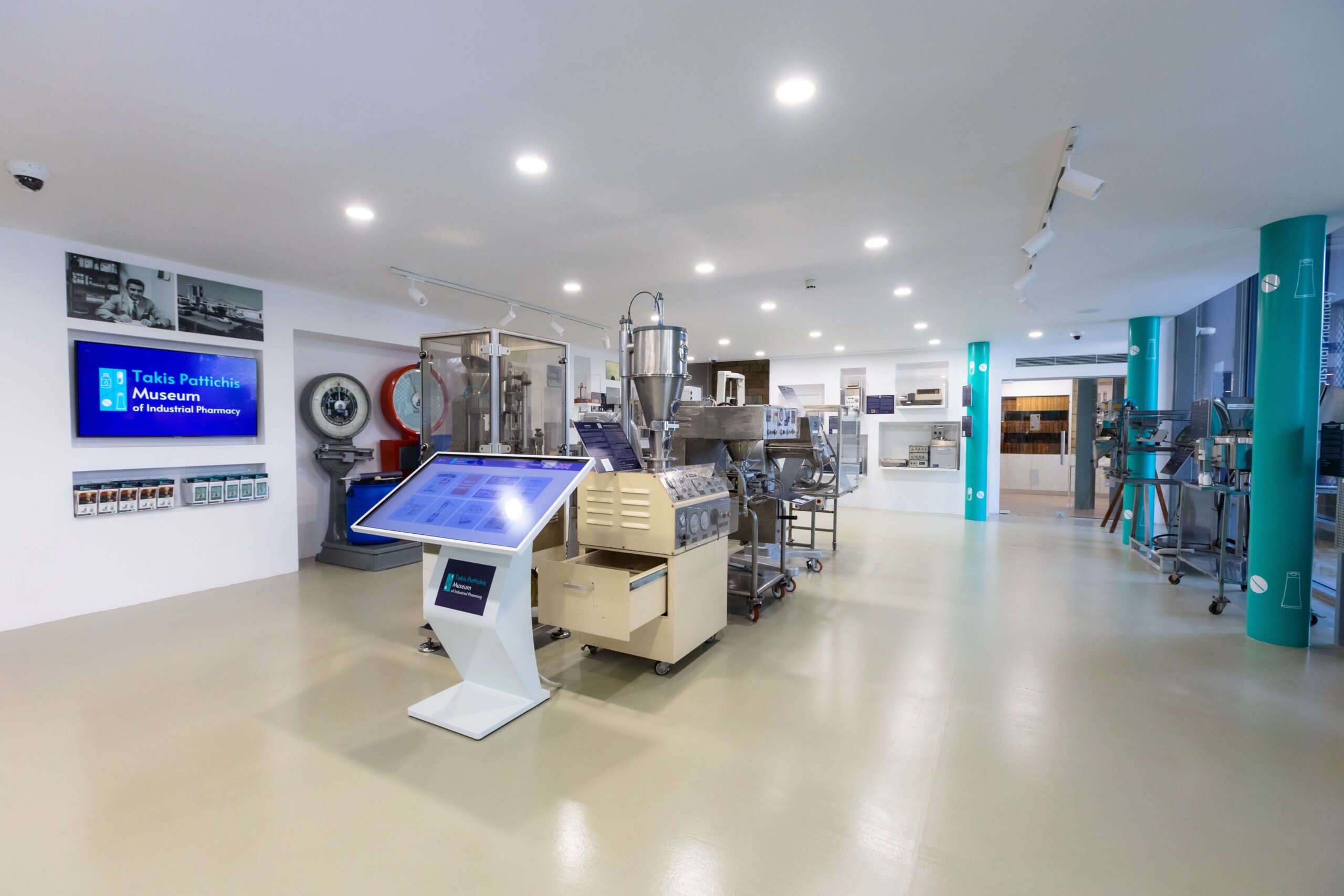
Established in 2022 by the Charalambos & Elena Pattihis Foundation, the Takis Pattichis Museum of Industrial Pharmacy is the only museum of its kind in Cyprus and probably in the whole world.
The Museum features an eclectic selection of scientific exhibits dedicated to the industrial manufacturing and analysis of medicines and it stands as a tribute to the history of the Cyprus Pharmaceutical Industry and to its founder – Mr. Takis Pattichis.
Starting out in the 1960’s, Takis Pattichis’ vision was to establish the manufacturing and exporting of pharmaceuticals right here in Cyprus, something which he achieved – making Cyprus known as a country manufacturing high-tech products in over 100 other countries.

Visitors of the Museum have the unique opportunity to:
 Learn about the machinery and processes used to manufacture pharmaceutical dosage forms like capsules, tablets, gels / creams / ointments, and syrups.
 Discover some of the relevant analytical instruments and other testing apparatuses used in monitoring and controlling the quality of medicines.
 Explore the development of weighing instruments and see how they have evolved over a period of more than 120 years.
 See original versions of historic books, manuals, guides, and reference books related to Chemistry and to Industrial Pharmacy, some of which date back to the 19th century.
 Understand the complicated manufacturing methods that pharmaceutical companies use to produce the medicines we consume.

All of the Museum’s exhibits have descriptions in both Greek and English as well as QR codes that open up web pages with information and pictures of each individual exhibit.

The Museum also includes an interactive touch screen with many interesting topics including a simple yet extensive Guide to Industrial Pharmacy, as well as posters explaining the process steps of manufacturing various pharmaceutical dosage forms.

The Museum’s main TV screen shows visitors an interesting video on the biography of Takis Pattichis and on the history of the Cyprus Pharmaceutical Industry.

Access: By public transport, by car (parking available near-by), on foot. There are no stairs in the display area of the Museum, so it is suitable for pushchairs / prams and wheelchair users.

Children: The Museum is ideally suitable for children of school age, and children below the age of 12 should be accompanied by an adult. 

Amenities: The Museum is located in the heart of the historic Limassol Old Town at the Carob Mill premises. As such, there are many cafes and restaurants in the adjacent buildings, as well as public toilets nearby in the Carob Mill main building itself.

Website:www.pattichismuseum.cy
 

Region: Lemesos (Limassol)
Address: Vasilissis Street, Limassol 3042 (on the pedestrian street behind the Limassol Castle) 
GPS coordinates: Lat: 34.66782 Lon: 33.03096
Contact No: For any questions, private event inquiries or additional information required, please contact the Museum directly at [email protected]
Operating Hours: Tuesday – Saturday: 09:30 – 18:00
Sunday: 9:30 – 17:30
Operating Period: All year round.
Closed on Monday and on public holidays
Entrance Fee: Free


Kavos (en boucle) – région d’Ammochostos (Famagouste), Parc national forestier du Cap Gkreko Sentiers nature

Coordonnées du point de départ: Lat: 34.963785 Lon: 34.067116
Coordonnées du point d’arrivée: Lat: 34.963785 Lon: 34.067116
Altitude du point de départ: 64m
Altitude maximale: 70m
Altitude minimale: 64m
Point de départ: Ancienne carrière.
Distance: 1.2 km
Durée approximative: 45 minutes
Niveau de difficulté: 1


Centres d’intérêt: Le sentier est situé au coeur du parc national forestier du Cap Gkreko, site du réseau Natura 2000. Le sentier traverse un paysage composé de pins et puis une végétation arbustive basse. Tout au long de l’itinéraire, se trouvent des points de vue à perdre le souffle; le plus impressionnant étant celui du sommet de la colline, d’où vous pourrez apprécier une vue panoramique de la nature. A l’est, vous pourrez voir la pointe du cap Pedalio où se situent le phare et les installations d’une station de radio française, la SOMERA; à l’ouest, la station balnéaire d’Ayia Napa tandis qu’au nord se trouve la zone principale du parc national forestier et enfin au le sud, vous pourrez admirer les eaux bleues et les côtes abruptes. Les amateurs d’escalade apprécieront les rochers impressionnants du côté sud de la colline. Le sentier connecte ensuite avec le sentier des «Sea Caves – Agioi Anargyroi».

Flore: Genévrier de Phénicie (Juniperus phoenicea), lentisque pistachier (Pistacia lentiscus), thym (Thymus capitatus), Pimprenelle épineuse (Sarcopoterium spinosum), Chêne doré (Bosea cypria).

Monastère de Trooditissa – Foini (linéaire) – région de Lemesos (Limassol), forêt du Troodos Sentiers nature

Coordonnées du point de départ: Lat: 34.912177 Lon: 32.837174
Coordonnées du point d’arrivée: Lat: 34.896838 Lon: 32.837357
Altitude du point de départ: 1,330m
Altitude maximale: 1,330m
Altitude minimale: 944m
Point de départ: Route principale Platres – Prodromos.
Distance: 4.5 km
Durée approximative: 2 heures
Niveau de difficulté: 1


Centres d’intérêt: Le sentier suit la route forestière qui relie le monastère de Trooditissa au le village de Foini et offre, tout au long du sentier, une vue magnifique sur ce beau village. Le sentier traverse la rivière de Trooditissa et vous mène à la cascade Hantara (huit mètres de haut), puis passe devant des roches verticales avant de teriner le parcours sur la  la route Foini-Agios Dimitrios, à la sortie de Foini. L’intégralité du sentier se trouve dans le parc national forestier du Troodos, qui est un site du réseau Natura 2000.

Flore: Pin de calabre (Pinus brutia), arbousier (Arbutus adrachnae), et chêne doré endémique (Quercus alnifolia).

Fragma (barrage) de Prodromos – Stavroulia (linéaire) – Régions de Lemesos (Limassol) / Lefkosia (Nicosie), forêt du Troodos Sentiers nature

Coordonnées du point de départ: Lat: 34.947845 Lon: 32.847256
Coordonnées du point d’arrivée: Lat: 34.971462 Lon: 32.862341
Altitude du point de départ: 1,592m
Altitude maximale: 1,592m
Altitude minimale: 1,262m
Point de départ: Sur la route principale de la place de Troodos – Prodromos, un peu plus loin du barrage de Prodromos, à 8km de la place de Troodos et à 3 km de Prodromos. Vous pouvez choisir entre deux itinéraires différents sur la route de Prodromos – Agios Nicolaos (Saint-Nicolas), puis deux destinations différentes.
Distance: (a) 4.5 km / (b) 5.5 km
Durée approximative: 1.5 – 2 heures
Niveau de difficulté: 3 (Haut degré de difficulté, terrain très escarpé, terrain très irrégulier et abrupt). Pas approprié pour les petits enfants.


Centres d’intérêt: Le sentier offre une vue magnifique sur la baie de Morfou, la chaîne montagneuse du Troodos, et une vue panoramique des tunnels abandonnés d’anciennes mines de chrome. Le sentier traverse une forêt de pins noirs d’une extrême densité. Il se situe dans le Parc National Forestier du Troodos. Sur le versant ouest du barrage, on trouve l’aire de pique-nique «Fragma Prodromou» [signifiant «barrage de Prodromos» en français]; l’aire de pique-nique de Marathos, elle, est située sur la route Agios Nikolaos – Prodromos.

Flore: Nepeta du Troodos( Nepeta troodi), germandrée de Chypre (Teucrium cyprium), alysse du Troodos (Alyssum troodi).

Faune:

MAMMIFERES: Renard, lièvre, hérisson.

OISEAUX: Aigle de Bonelli, geai des chênes, pigeon ramier, perdrix, fauvette de Chypre (Εndémique), traquet de Chypre (Εndémique).

REPTILES: Vipère de Chypre, serpent de Chypre (endémique).

Prodromos – Zoumi (linéaire) – régions de Lemesos (Limassol) / Lefkosia (Nicosie), forêt du Troodos Sentiers nature

Coordonnées du point de départ: Lat: 34.952183 Lon: 32.833700
Coordonnées du point d’arrivée: Lat: 34.963214 Lon: 32.849812
Altitude du point de départ: 1,499m
Altitude maximale: 1,475m
Altitude minimale: 1,314m
Point de départ: L’aire de jeux pour enfants à Prodromos.
Distance: 3 km
Durée approximative: 1 – 1.5 heure
Niveau de difficulté: 2


Centres d’intérêt: Le sentier traverse une forêt de pins noirs (Pinus nigra subsp. Pallasiana). A divers endroits le long du sentier, il y a des vues panoramiques de la vallée de Marathasa, la baie de Morfou, le Monastère de Kykkos, Tripylos et Vouni Panagias. A Zoumi, le chemin rejoint le sentier de Frakti Prodromos – Stavroulia. Le sentier peut aussi former une boucle si vous choisissez la route Prodromos – Troodos, avec une distance supplémentaire de 2,7 km. Le sentier est situé dans le Parc National Forestier du Troodos.

Flore: Scabieuse pterocephala communément appelée ‘Manouthkia’ * (Pterocephalus multiflorus subsp. multiflorus – petit arbuste à feuilles persistantes aux fleurs rose pale), sauge (Salvia willeana), germandrée de Chypre (Teucrium cyprium)

Faune:

MAMMIFERES: Renard, lièvre, hérisson.

OISEAUX: Aigle de Bonelli ,geai des chênes, pigeon ramier, perdrix, fauvette de Chypre (endémique), traquet de Chypre (endémique).

REPTILES: Vipère de Chypre, couleuvre de Montpellier.